Alberta Bryophyte, Photo: Richard Caners
Monitoring of land and biodiversity helps Albertans and decision-makers understand the cumulative impact of Alberta’s growing human population and economy on landscapes, native plants and animals.
Alberta’s landscapes are continually changing, and Alberta’s land and biodiversity supports a wide variety of uses and activities. Urban and industrial land uses continue to expand throughout the province. The province’s many parks and natural areas are popular destinations for nature appreciation and recreation. Also, many species and natural resources support important economic activities and lifestyles, such as fishing, hunting, mining, agriculture, tourism and forestry.
Collaboration
Monitoring of Alberta’s biodiversity and land monitoring, including planning, delivery, evaluation and reporting activities, is a collaborative effort. Organizations involved in biodiversity and land monitoring include AEMERA staff, the Alberta Biodiversity Monitoring Institute (ABMI), Federal and Provincial government departments and agencies, researchers and selected contractors.
Why we monitor
Frog, Photo: Arnold Janz
Biodiversity and land monitoring considers scientific, policy, and stakeholder drivers.
Academic researchers can both benefit from and inform monitoring. Academics may initiate research based on signals from monitoring data, or may use this data to enhance their research. Being connected to scientific literature allows AEMERA to respond to emerging ecological issues, for example global patterns and health of different species. Industry or commercial developments may use monitoring data to inform their management activities.
Legislation and policies can identify strategies and outcomes that require an understanding of the current condition of the environment and trends over time. The Canadian Biodiversity Strategy provides a guide for conserving biodiversity and ensuring sustainable use of biological resources. Governments and Albertans may use monitoring data and information to understand if policies, such as the draft Biodiversity Policy, and actions are achieving the strategic directions contained in the Strategy. Other Alberta policy and law specifies biodiversity information needed for planning (e.g., Land-use Framework) or sound environmental practice during resource development (e.g., operating approvals under the Environmental Protection and Enhancement Act).
A better understanding of the status of Alberta’s land and biodiversity can affect how we, as Albertans, interact with our environment. We may change how we undertake recreation activities, lessening our impact or becoming part of citizen science initiative. The information may also affect how Albertans garden, enticing people to plant native species that support indigenous butterflies or bird species.
Monitoring itself
Coverage and intensity of land and biodiversity monitoring varies, including both long-term monitoring and shorter-term studies. Primary monitoring information may indicate a presence of issues and specific knowledge gaps, which can trigger focused studies to address the information need. Primary data collection may be ground-based, such as plot-based estimates, or remotely sensed using technologies like aerial photography, LiDAR or satellite imagery. These data sources often assist integration of biodiversity and landscape analysis.
Athabasca River upstream Grande Rapids Shelter, Photo: Brian Jackson
Province-wide
Province-wide monitoring of Alberta’s landscapes helps us understand changes to land quality and quantity, over time. It is conducted to determine status and trends in habitat composition (including inventory of forests, range and wetlands), habitat disturbance, reclamation and remediation and soil quality. Alberta monitors its biodiversity at genetic, species and ecosystem levels, but like other jurisdictions, places greatest effort at species and ecosystem levels. Combined, land and biodiversity monitoring is designed to provide status and trend information related to Alberta’s biodiversity, habitats and habitat disturbance.
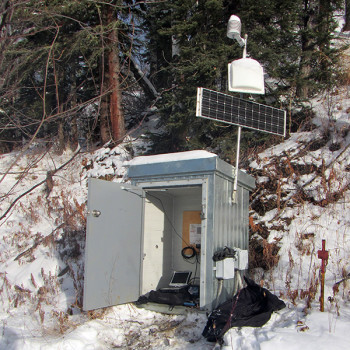
Across Alberta, a grid-based network of permanent sites is monitored on a 5-year re-measurement cycle, with over 300 sites potentially being measured per year. Every node on the network consists of a pair of sites – one terrestrial and one nearby wetland. At each site, standard upland or wetland monitoring protocols are applied for ecological characterization and measurement of up to 2200 species including vascular plants, mosses and lichens, birds, soil mites, winter-active mammals and aquatic invertebrates. Status reports on this monitoring are posted at www.abmi.ca.
Enhancing monitoring for regional, issue-based or species-specific information needs…
Long-term or short-term enhancement of monitoring is often used to address specific information needs. This enhancement can be implemented province-wide or regionally.
Photo: Richard Caners
Two main criteria - status and allocation for harvest - influence the decision to undertake species-specific monitoring and methods implemented. Species that are allocated for harvest are monitored in relation to a number of factors, including resource pressures, public observations and response, and time since last survey. Results contribute to a publically accessible database: http://esrd.alberta.ca/fish-wildlife/fwmis/default.aspx. Species detected as sufficiently abundant in the grid-based network of permanent sites receive an “intactness index” report; otherwise, their frequency of occurrence is reported. Every five years, Alberta contributes this information to a National Status of Wild Species report, in which species are sorted into categories of concern. Specific monitoring protocols are being developed for many of the boreal species of concern, and programs are in place for species legally listed as threatened or endangered under Alberta or federal legislation. For example, all woodland caribou populations are trend-monitored through a “lambda” technique involving radio-collaring of a sub-sample and observations on cow/calf ratios. In the oil sands area, absolute population estimates for some herds are being attempted through a DNA-typing method based on analysis of scat. Similarly, grizzly bear populations in the Foothills are being estimated based on DNA in hair samples secured from snags.
Knowledge gaps or information needs relevant to key issues have led to specific monitoring to obtain in-depth understanding of soil acidification, changes of provincial footprint, and success of reclamation. Soil acidification indicator monitoring (pH and soluble ions) facilitates long-term trends analysis related to the effects of acid deposition. Long-term ecological recovery monitoring at reclaimed industrial sites generates data on soil and vegetation indicators to enable statistical tracking of landscape recovery towards background conditions. Footprint change analysis informs our understanding of landscape level cumulative impacts and trajectories from a variety of land-use activities. In the oil sands area, where there are significant development and growth pressures, enhanced monitoring of habitat and footprint characterizes vegetative recovery in reclaimed and re-forested landscapes. This work correlates vegetation patterns with ground-based measurements of biodiversity and successional changes to track recovery and reclamation of disturbed land.
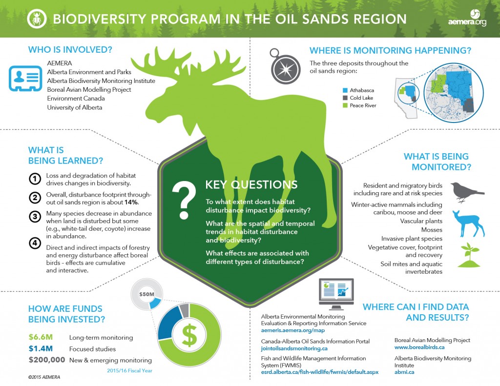
Biodiversity Program in the Oil Sands
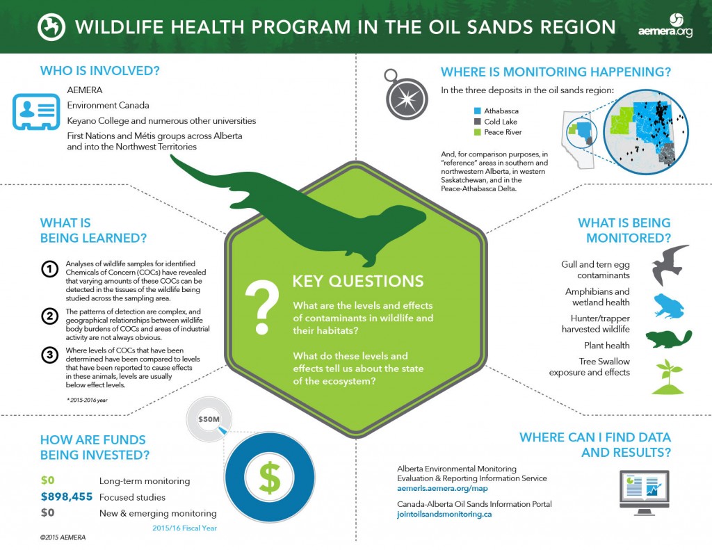
Wildlife Health Program in the Oil Sands